Description
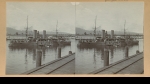
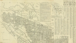
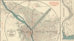
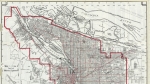
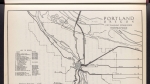
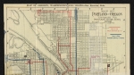
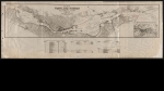
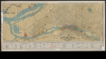
Map of downtown Portland, dated January 1912, showing the area between Taylor St., the Willamette River, Clay St. and 2nd St. Waterfront businesses are labeled with the owner and building condition. The materials used to pave sidewalks and streets is indicated on most blocks. The map shows the tracks for streetcars, interurban railways and commercial railways. Named railway companies are: Oregon Electric Railway, United Railway, Southern Pacific Company and Portland Railway Light and Power Company. The map also features the Oregon Electric Railway Depot at Columbia and Front (now SW Naito Parkway). Visit City of Portland Archives for more https://efiles.portlandoregon.gov/record/3911289
Related content


Collections with this item
Details
Contributors
Digital Publisher
Subject.Topic
Subject.Place
Language
Rights & Usage
Public domain (this work is believed to be free of known restrictions under copyright law).
Identifier
- PUmap_000002
Type
Date.Range
Format.Original
File format
Shelf.Location
- A2009-018, M/1773
Add new comment