
Description
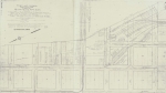
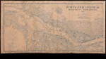
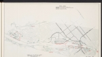
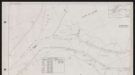
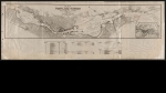
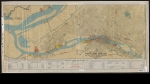
Map of Willamette River bridges in Central Portland, dated December 1909. It shows river depth soundings, dock names and streetcar lines. A table lists the heights of bridges above low water, and the grades of bridge approaches. The map shows a proposed tunnel, which would have run underneath the Willamette River from NW Overton St. and NW 9th Ave. to N. Albina St. The Broadway Bridge is on the map, even though it was not actually built until 1913, four years after the date of this map.
Download Files

Related content


Collections with this item

Details
Contributors
Digital Publisher
Subject.Place
Language
Rights & Usage
Public domain (this work is believed to be free of known restrictions under copyright law)
Identifier
- JWmap_000010
Type
Date.Range
Format.Original
File format
Shelf.Location
- OREGON 627.3 P85L
Add new comment