Description
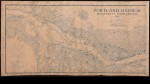
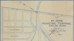
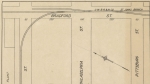
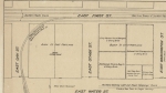
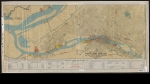
Undated map of the Willamette River from the Clackamas County line to the southern tip of Sauvie Island, focusing on river transportation and river-side industry. The map shows ferries, bridges, docks, shipbuilding facilities, railroads and streetcar lines. A planned municipal freight and grain terminal is outlined in the St. Johns neighborhood. The map was likely was published sometime after 1913 when the Broadway Bridge was built, and sometime before 1919, when the St. Johns Municipal Terminal was built.
Download Files
Related content

Collections with this item

Details
Contributors
Digital Publisher
Subject.Topic
Subject.Place
Language
Rights & Usage
Rights undetermined (the copyright and related rights status of this work is unknown).
Identifier
- XXmap_000028
Type
Date.Range
Format.Original
File format
Shelf.Location
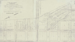
- Bound in a folder with Oregon harbor maps - third sheet
Add new comment