Description
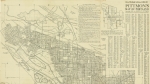
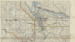
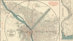
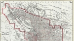
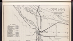
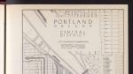
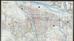
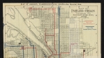
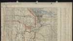
Map of heavy rail lines in the western part of the Portland metropolitan area, dated June 27, 1940. The map also shows an interurban line running south from downtown Portland to Jennings Lodge in Clackamas County. Township, range and section lines are on the map, as are the Willamette and Tualatin rivers, and Lake Oswego. Visit City of Portland Archives for more https://efiles.portlandoregon.gov/record/4083131
Related content
Collections with this item
Details
Contributors
Digital Publisher
Subject.Topic
Subject.Place
Language
Rights & Usage
Rights undetermined (the copyright and related rights status of this work is unknown).
Identifier
- PUmap_000021
Type
Date.Created
June 27, 1940
Date.Range
Format.Original
File format
Shelf.Location
- A2010-008, M/1838
Add new comment