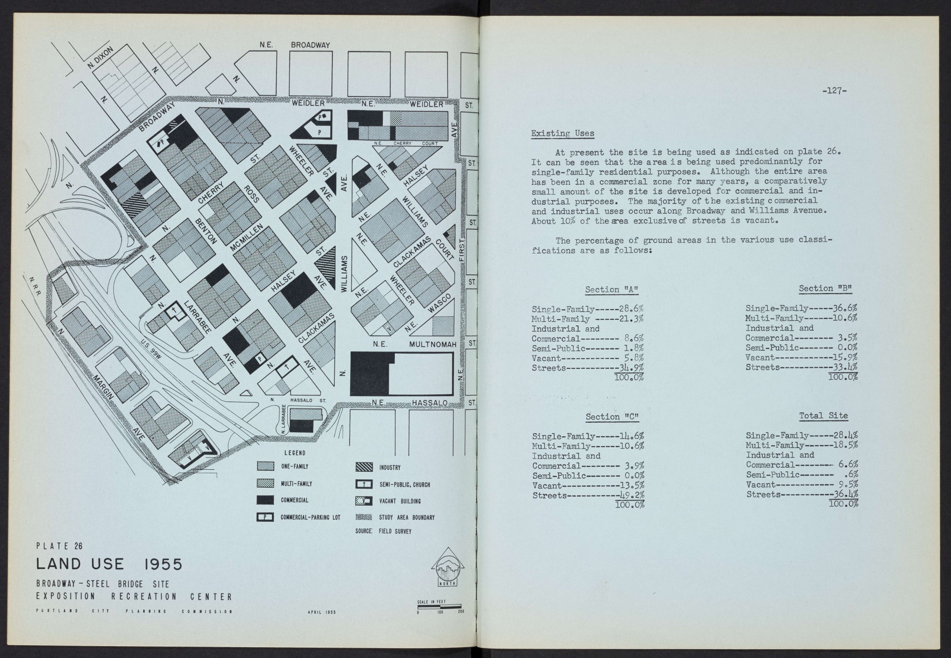
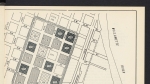
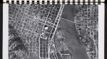
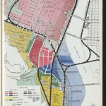
-125-
EïIStI NG CONDITIONS
Location
For the purposes of this stucfy the Broadway-Steel Bridge site is defined as the area bounded generally by N. Broadway, N.E. Weidler, N.E. First, N.E. Hassalo and the Willamette River. To facilitate studies and presentation of data the site is divided into three sections as shown on plate 25.
This is the closest East Side site to the downtown business core and has many of the advantages inherent in a downtown site. The Broadway-Steel Bridge area is not within convenient walking distance of the shops and hotels of the westside business district, however, it is close enough so that the time and cost of transportation from the center do not constitute a major disadvantage. The distance from-the site to the proposed Lloyd Shopping Center and development, which include plans for a future hotel, is eleven blocks.
This site is located about 0.8 of a mile from he city's center of population which means near optimum traveling distances for all sections of the city's population.
Topography
The ground in this area slopes uniformly down at approximately a yfL grade from the northeast to -the southwest, terminating in a relatively steep bank of 30-lj.O feet down to the river. Midway in the slope of this bank is a short level interval on which railroad tracks are constructed. A difference of approximately UO feet exists between the northeast and southwest comers of section "A".
Areas Section "A” Section "B” Section "C" Total
Block Area 13.1 Acres 6.7 Acres 2.5 Acres 22.3 Acres
Street Area 7. It Acres 3.1 Acres 2.5 Acres 13.0 Acres
Gross Area 20.5 Acres 9.8 Acres 5.0 Acres 35*3 Acres
N. E. BROADWAY
LEGEND
ONE-FAMILY INDUSTRY
MULTI-FAMILY m SEMI-PUBLIC, CHURCH
COMMERCIAL □a VACANT BUILDING
COMMERCIAL-PARKING LOT STUDY AREA BOUNDARY
source: FIELD SURVEY
PLATE 26
LAND USE 1955
BROADWAY - STEEL BRIDGE SITE E X P 0 S I T I 0 N R EC REATION
PORTLAND CITY
P L A N N I N C
CENTER
C O N NI S $ 1.0 N
SCALE IN FEET
100 200
-127-
Existing Uses
At present the site is being used as indicated on plate 26. It can be seen that the area is being used predominantly for single-family residential purposes« Although the entire area has been in a commercial zone for many years, a comparatively small amount of the site is developed for commercial and industrial purposes. The majority of the existing commercial and industrial uses occur along Broadway and Williams Avenue. About 10$ of the area exclusivecf streets is vacant.
The percentage of ground areas in the various use classifications are as follows;
Section "A"
Single - Family---28.6$
Multi-Family------21.3$
Industrial and
Commercial---------8«6$
Semi-Public--------1.8$
Vacant-------------5.8$
Streets----------3li«9$
100.0$
Section HCn
Single- Family----llu 6$
Multi -Family-----10.6$
Industrial and
Commercial------— 3 «9$
Semi-Public------— 0.0$
Vacant------------13 «5$
Streets-----■-----1l9.2$
100.0$
Section "BM
Single-Family-----36.6$
Multi-Family------10 • 6$
Industrial and
Commercial---------3.5$
Semi-Public--------0.0$
Vacant-----------15« 9$
Streets----------33»ii$
100.0$
Total Site
Single -Family--2 8 .U$
Multi-Family------18.5$
Industrial and
Commercial---------6.6$
Semi-Public-------- .6$
Vacant—---------— 9 «5$
Streets----------36. k%
100.0$
N. E. BROADWAY
source: us. census of housinc,
70—100% 1950
PLATE 27
SUBSTANDARD
BROADWAY - STEEL BRIDGE SITE EXPOSITION RECREATION
DWELLINGS
CENTER
ISSi 0 100 200
129“
Character of Area
Considerations of substandard dwellings and owner occupancy-in the area, as indicated by the 1950 US Census Block Statistics, are shown on plates 27 and 28.
According to the 1950 Census this area has a total of 1*76 dwelling units, of which 221* or 1*7$ are occupied by non-white families. Approximately h% of the dwelling units are overcrowded as defined by the Portia nd Housing Code, compared to the city-wide average of 2.3$. The average number of persons per household is 2.75 compared to 2.81 for all of Portland.
The dwelling units in section "A" are 2l*$ owner occupied,
33$ in section nB" are owner occupied and 16$ in section "C" are owner occupied. The city average of owner occupancy is 57$»
All of the residential structures on the site were constructed prior to 1920, but several new commercial and light industrial buildings have been constructed recently. There were approximately 70 less dwelling units in the area in 1950 than there were in 19l*0, not including the units taken for the construction of the new US99 Ti highway. As defined by the 1950 Census, 33$ of the dwelling units on the site are substandard,
3U$ of those in section "A" are substandard, 5$ of those in section "B" are substandard and 6l$ in section "C" are substandard.
In general, the area is one having predominantly old single and multiple family homes, occupied by average sized families having an educational and income level somewhat below tne city average.
Add new comment