Description
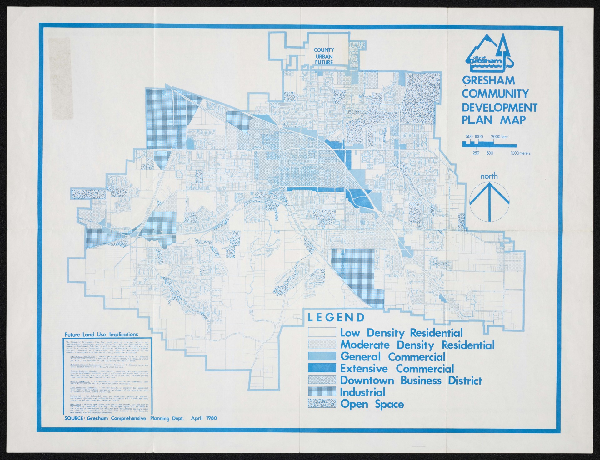
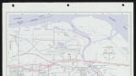
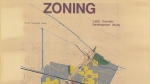
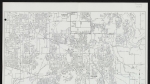
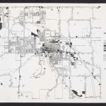
A map of Gresham, Oregon showing land use planning information, dated April 1980. Shading indicates residential, commercial and industrial zones in the city of Gresham. The city limits are shown with a heavy blue line. The reverse of the map shows information from Gresham's proposed Community Comprehensive Plan, with a small inset Community Development Code Map.
Related content
Collections with this item

Details
Transcription
COUNTY
URBAN FUTUR
30000000C JOOOOOOÖi iOOOOOOOt ■QOOOOOOC “ aoooooc gooooot □00000(1 □ooooof
■Booooot >ooi___
hiïnnnnrid pnonn^
s uui QOOC
Mr
eranm
•tMC-P-OOOOC
VjöOOOOq
UCfooooa < >©ooo<x]
UsgB
US
ipiSDS
Jem
—iiX^oocf fcfcfl —-----------—
mi
JPOOOO ^iiOOOOO . '<5000000
■oooooooc ■dooooqooc
*5000000000! fV^fÖOOOOOOOOOO!
X i^Oooooooooooo / OVOOOOOOOOOOOOOO! i^oooooc’ooooooooq
Si
d-i IrtrilB
O ° ° O O] O O O OO <
1F=?^A°o°oWo°<
vO o o o oj
skSkbî
m
lPo°o0o0o0oWo°a ÿî p o o o o o^o^qToT£
¡§1 ■anli 1H
l^Kli
SBÜ
PitmFij • îf5".' ËiStf
H ■■ggH
s>$$ag
ffipi Sii [
_#)0
rrX^
r X ;
¿¡il
■l.ji | .1, .I T » |
IiIbä I!I
ooooU m oooooi
'OC ■ T00©0©(
221 '©or-''-
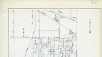
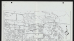
Future Land Use Implications
The Community Development Plan Map, based upon the findings, policies and implementation strategies, depicts lot-by-lot land use designations. The Community Development Code Map is used in association, to determine whether a parcel is within an ESTABLISHED, DEVELOPING, REDEVELOPING or SPECIAL PURPOSE DISTRICT (Hillsides or Floodplains). The land use designations of the Community Development Plan Map may be briefly summarized as follows:
Low Density Residential - maximum permitted densities up to 8.7 dwelling units per acre within 275 feet of a Collector Street, 4.9 dwelling unites per acre on the remainder of the Low Density Residential areas.
GRESHAM
COMMUNITY
DEVELOPMENT PLAN MAP
500 1000 2000 feet
250 500
1000meters
north
Hrffii
LEGEND
OOOOOOOOOOOOOOOOQO QOQOOOOOOOOOOOQOOO 'OOOOOOOOOOOOOOOOOO DOOOOOOOOOOOOOOOOOC ^ DOOOOOOOOOOOOOOOOOOC
inn
«¡Hi*
Low Density Residential Moderate Density Residential I General Commercial Extensive Commercial Downtown Business District Industrial
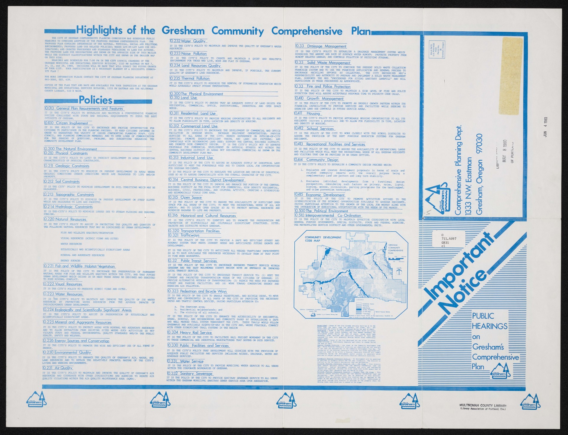
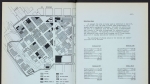
Highlights of the Gresham Community Comprehensive Plan
10.232Water Quality ______________
THE CITY OF GRESHAM COMPREHENSIVE PLANNING COMMISSION HAS SCHEDULED PUBLIC HEARINGS TO CONSIDER ADOPTION OF THE PROPOSED GRESHAM COMPREHENSIVE PLAN. THE PROPOSED PLAN CONTAINS INVENTORIES OF THE NATURAL, PHYSICAL, SOCIAL AND POLITICAL ENVIRONMENTS; PROPOSES LAND USE RELATED POLICIES; MAKES LOT-BY-LOT LAND USE DESIGNATIONS; AND CREATES PROCEDURES AND STANDARDS PERTAINING TO LAND USE ACTIONS. THE PROPOSED LAND USE DESIGNATIONS ARE SHOWN ON THE OPPOSITE SIDE OF THIS MAILER WHILE THE DISTRICT CLASSIFICATIONS WITHIN THE CITY ARE SHOWN ON THE SMALLER MAP ON THIS SIDE.
HEARINGS ARE SCHEDULED FOR 7:00 PM IN THE CITY COUNCIL CHAMBERS OF THE GRESHAM MUNICIPAL AND EDUCATIONAL SERVICES BUILDING, 1333 NW EASTMAN ON MAY 7,
14, 21, and 28, 1980. DECISIONS WILL BE MADE THAT WILL DIRECT THE FUTURE GROWTH OF YOUR CITY. YOUR PARTICIPATION IS A NECESSARY ELEMENT OF A SUCCESSFUL COMMUNITY PLAN :
FOR MORE INFORMATION PLEASE CONTACT THE CITY OF GRESHAM PLANNING DEPARTMENT AT 661-3000, EXT. 439.
COPIES OF THE PLAN TEXT AND MAPS ARE AVAILABLE FOR YOUR INSPECTION AT THE GRESHAM MUNICIPAL AND EDUCATIONAL SERVICES BUILDING, 1333 NW EASTMAN AND THE MULTNOMAH COUNTY LIBRARY, 410 N MAIN.
Policies
10.013 General Plan Requirements and Features"
IT IS THE CITY’S POLICY TO ESTABLISH AND MAINTAIN A COMPREHENSIVE PLANNING PROCESS CONSISTENT WITH STATE AND REGIONAL REQUIREMENTS TO SERVE THE BEST INTERESTS OF GRESHAM.
10.100 Citizen Involvement
IT IS THE POLICY OF THE CITY TO ENCOURAGE AND PROVIDE OPPORTUNITIES BO® CITIZENS TO PARTICIPATE IN THE PLANNING PROCESS: TO KEEP CITIZENS INFORMED IN ORDER TO UNDERSTAND THE VARIETY OF ISSUES CONFRONTING PLANNING STAFF, CITY COUNCIL, AND PLANNING COMMISSION MEMBERS: AND TO OPEN LINES OF COMMUNICATION FOR THE SHARING QF QUESTIONS, PROBLEMS, AND SUGGESTIONS REGARDING THE COMMUNITY DEVELOPMENT PLAN.
10.200 The Natural Environment
IT IS THE CITY'S POLICY TO LIMIT OR PROHIBIT DEVELOPMENT IN AREAS EXHIBITING CHARACTERISTICS OF PHYSICAL CONSTRAINTS.
10.211 Geologic Constraints
IT IS THE CITY'S POLICY TO MINIMIZE OR PREVENT DEVELOPMENT IN AREAS WHERE GEOLOGIC CONDITIONS CREATE CONDITIONS WHICH ARE HAZARDOUS TO LIFE AND/OR PROPERTY.
10.212 Soil Constraints
IT IS THE CITY' POLICY TO MINIMIZE DEVELOPMENT ON SOIL CONDITIONS WHICH MAY BE HAZARDOUS.
10.213 Topographic Constraints
IT IS THE CITY'S POLICY TO MINIMIZE OR PREVENT DEVELOPMENT ON STEEP SLOPES WHICH ARE HAZARDOUS TO LIFE AND PROPETRY.
10.214 Hydrologic Constraints
IT IS THE-CITY’S POLICY TO MINIMIZE LOSSES DUE TO STREAM FLOODING AND SEASONAL PONDING.
10.220 Natural Resources
IT IS THE CITY’S POLICY TO ASSIST IN PROTECTING THE QUALITY AND QUANTITY OF THE FOLLOWING NATURAL RESOURCES THAT MAY BE DIMINISHED BY URBAN DEVELOPMENT:
FISH AND WILDLIFE HABITATS/VEGETATION
VISUAL RESOURCES (SCENIC VIEWS AND SITES)
WATER RESOURCES
ECOLOGICALLY AND SCIENTIFICALLY SIGNIFICANT AREAS MINERAL AND AGGREGATE RESOURCES ENERGY SOURCES
10.221 Fish and Wildlife Habitat/Veaetation
IT IS THE POLICY OF THE CITY TO ENOOURAGE THE PRESERVATION OF PERMANENT NATURAL AREAS FOR FISH AND WILDLIFE HABITATS WITHIN THE CITY, AND THAT FUTURE URBAN DEVELOPMENT WHICH OCCURS IN OR NEAR THESE AREAS BE DESIGNED AND EXECUTED TO POSE MINIMAL CONFLICT.
10.222 Visual Resources
IT IS THE CITY'S POLICY TO PRESERVE SCENIC VIEWS AND SITES.
10.223 Water Resources
IT IS THE CITY'S POLICY TO MAINTAIN AND IMPROVE THE QUALITY OF ITS WATER RESOURCES BY PROTECTING WATER RESOURCES FROM THE ADVERSE IMPACTS OF INDISCRIMINATE URBAN DEVELOPMENT.
10.224 Ecologically and Scientifically Significant Areas
IT IS THE CITY'S POLICY TO ASSIST IN PRESERVATION QF ECOLOGICALLY AND SCIENTIFICALLY SIGNIFICANT AREAS.
10.225 Mineral and Aggregate Resources
IT IS THE CITY'S POLICY TO PROTECT AREAS WITH MINERAL AND AGGREGATE RESOURCES AND TO ALLCW EXTRACTION FRCM EXISTING SITES WHERE SUCH ACTIVITIES DO NOT VIOIATE STATE AND FEDERAL ENVIRONMENTAL QUALITY STANDARDS AND/OR THE PUBLIC HEALTH, SAFETY AND WELFARE.
10.226 Energy Sources and Conservation
IT IS THE CITY'S POLICY TO PROMOTE THE WISE AND EFFICIENT USE OF ALL PC|RMS OF ENERGY.
10.230 Environmental Quality^
IT IS THE CITY'S POLICY TO ENHANCE THE QUALITY OF GRESHAM'S AIR, WATER, AND LAND RESOURCES AND TO RETAIN THE RELATIVELY PEACEFUL NATURE OF THE CITY'S LIVING AND WORKING ENVIRONMENTS.
10.231 Air Quality
IT IS THE CITY'S POLICY TO MAINTAIN AND IMPROVE THE QUALITY OF GRESHAM'S AIR RESOURCES AND COOPERATE WITH OTHER JURISDICTIONS AND AGENCIES TO REDUiCE AIR QUALITY VIOLATIONS WITHIN THE AIR QUALITY MAINTENANCE AREA (AQMA) .
IT IS THE CITY'S POLICY TO MAINTAIN AND IMPROVE THE QUALITY OF GRESHAM'S WATER RESOURCES.
10.233 Noise Pollution
IT IS THE CTl'Y' S POLICY TO CREATE AND MAINTAIN A QUIET AND HEALTHFUL ENVIRONMENT FOR THOSE WHO LIVE, WORK AND PLAY IN GRESHAM.
10.234 Land Resources Quality
IT IS THE CITY'S POLICY TO MAINTAIN AND IMPROVE, IF POSSIBLE, THE CURRENT QUALITY OF GRESHAM'S LAND RESOURCES.
10.235 Thermal Pollution
IT IS THE CITY'S POLICY TO MINIMIZE THE REMOVAL OF STREAMS IDE VEGETATION WHICH WOULD ADVERSELY IMPACT STREAM TEMPERATURES.
10.300The Physical Environment __________________________
10.310 Land Use
IT IS THE CITY'S POLICY TO ENSURE THAT AN ADEQUATE SUPPLY OF LAND EXISTS EUR RESIDENTIAL, COMMERCIAL, OFFICE, INSTITUTIONAL, INDUSTRIAL AND OPEN SPACE NEEDS.
10.311 Residential Land Use
IT IS THE CITY'S POLICY TO PROVIDE HOUSING OPPORTUNITIES TO ALL RESIDENTS AND TO AUCW FLEXIBILITY IN TYPE, LOCATION AND DENSITY OF HOUSING.
10.312 Commercial Land Use
IT IS THE CITY'S POLICY TO ENCOURAGE THE DEVELOPMENT OF COMMERCIAL AND OFFICE FACILITIES IN GRESHAM WHICH: INCREASE EMLOYMENT OPPORTUNITIES; PROVIDE
SERVICES TO ALL AREAS OF THE CITY; REDUCE DEPENDENCE ON OUTSIDE-OF-CITY SERVICES; PROMOTE ENERGY-EFFICIENT TRAVEL AND IAND USE PATTERNS; ARE COMPATIBLE WITH NEIGHBORING LAND USES; SUPPORT THE CENTRAL BUSINESS DISTRICT; AND PROMOTE GOOD COMMUNITY DESIGN. IT IS THE CITY'S POLICY NOT TO APPROVE PROPOSALS PC® COMMERCIAL DEVELOPMENT CN ARTERIAL STREETS NOT WITHIN THE CENTRAL BUSINESS DISTRICT IN AREAS NOT DESIGNATED COMMERCIAL AS SHOWN ON THE COMMUNITY DEVELOPMENT PLAN MAP.
10.313 Industrial Land Use
IT IS THE POLICY QF THE CITY TO ASSURE AN ADEQUATE SUPPLY OF INDUSTRIAL LAND SUFFICIENT TO MEET THE FQRSEEABLE NEED AND TO CREATE LOCAL JOB OPPORTUNITIES EOR GRESHAM RESIDENTS.
IT IS THE POLICY OF THE CITY TO REGUIATE THE LOCATION AND DESIGN OF INDUSTRIAL USES SO AS TO ASSURE COMPATIBILITY WITH THE OVERALL CHARACTER OF THE CITY.
10.314 Central Business District Development
IT IS THE POLICY OF THE CITY TO IMPROVE AND ENHANCE THE POSTION OF THE CENTRAL BUSINESS DISTRICT AS THE FOCAL POINT FOR CCM4ERCIAL, HIOL DENSITY RESIDENTIAL, BUSINESS, CIVIC, PROFESSIONAL, AND CULTURAL ACTIVITY, CREATING A DIVERSIFIED AND ECONOMICALLY VIABLE CORE AREA.
10.315 Open Space
IT IS THE POLICY QF THE CITY TO ENSURE THE AVAILABILITY OF SUFFICIENT OPEN SPACE FOR AIL AREAS OF THE CITY; TO MEET THE RECREATIONAL NEEDS QF ALL AGE GROUPS; AND TO LOCATE OPEN SPACES SO AS TO PROTECT NATURAL RESOURCES AND MINIMIZE HAZARDS TO LIFE AND PROPERTY.
10.316 Historical and Cultural Resources
IT IS THE CITY'S POLICY TO IDENTIFY AND TO PROMOTE THE PRESERVATION AND PROTECTION OF HISTORICALLY AND CULTURALLY SIGNIFICANT STRUCTURES, SITES, OBJECTS AND DISTRICTS WITHIN GRESHAM.
10.320 Transportation Facilities
10.321 Trafficways_____________
IT IS THE POLICY OF THE CITY TO PROVIDE A SAFE AND EFFICIENT STREET AND ROADWAY SYSTEM THAT MEETS CURRENT NEEDS AND ANTICIPATED FUTURE GROWIH AND DEVELOPMENT.
IT IS THE POLICY OF THE CITY TO ANTICIPATE ALL NEEDED TRAFFICWAY IMPROVEMENTS SO AS TO HAVE AVAIIABLE THE RESOURCES NECESSARY TO DEVELOP THEM AT THAT POINT IN TIME WHEN WARRANTED.
10.32 Public Transit Services
IT IS THE POLICY OS’ THE CITY TO ENOOURAGE EXPANDED TRANSIT SERVICE WITHIN GRESHAM AND THE EAST MULTNOMAH COUNTY REGION WITH AN EMPHASIS ON IMPROVED LOCAL TRANSIT SERVICE.
IT IS THE POLICY OF THE CITY TO ENCOURAGE TRANSIT SERVICE TO: (1) MEET THE CURRENT AND PROJECTED TRANSPORTATION NEEDS OF THE CITIZENS OF GRESHAM; (2) PROVIDE ALTEENATIVE METHODS OF TRANSPGRATION; (3) REDUCE THE NEED FOR EXPANDED STREET AND PARKING FACILITIES; AND (4) WORK TOWARD CONSERVING ENERGY AND REDUCING AIR POLLUTION.
10.323 Pedestrian and Bicycle Ways
IT IS THE POLICY QF THE CITY TO ENABLE PEDESTRIANS, AND BICYCLE USERS, TO MOVE SAFELY AND CONVENIENTLY IN ALL PARTS OF THE CITY BY PROVIDING THE NECESSARY PATHS AND TRAFFIC CONTROL DEVICES, PAYING PARTIOJIAR ATTENION TO:
a. The downtown area;
b. Residential neighborhoods; and
c. The vicinity of all schools.
IT IS THE POLICY OF THE CITY TO ENHANCE THE ACCESSIBILITY OF RESIDENTIAL AREAS, SCHOOLS, AND NEIGHBORHOOD AND CC6MJNITY PARKS BY ESTABLISHING A SAFE AND WELL MARKED TRAIL SYSTEM THROUGHOUT THE CITY. THESE TRAILS WOULD FOLLOW GREENWAYS AND AVAILABLE RIGHTS-QF-WAY IN THE CITY AND, WHERE FEASIBLE, COM9ECT WITH OTHER SIGNIFICANT TRAIL SYSTEMS IN THE REGION
10.324 Heavy Rail Service
IT IS THE POLICY OF THE CITY TO FACILITATE RAIL FREIGHT MOVEMENT IN THE CITY TO THOSE COMMERCIAL AND INDUSTRIAL MANUFACTURERS THAT DEPEND ON SUCH SERVICE.
10.330 Public Facilities and Services
IT IS THE CITY'S POLICY THAT DEVELOPMENT WILL COINCIDE WITH THE PROVISION OF ADEQUATE PUBLIC FACILITIES AND SERVICES INCLUDING ACCESS, DRAINAGE, WATER AND SEWERAGE SERVICES.
10.331 _ Water Service
IT IS THE POLICY OF THE CITY TO PROVIDE MUNICIPAL WATER SERVICE TO ALL USERS WITHIN THE CORPORATE BOUNDARIES OF GRESHAM.
10.332 Sanitary Sewerage
IT IS THE POLICY OF THE CITY TO PROVIDE SANITARY SEWERAGE SERVICE TO ALL USERS WITHIN THE GRESHAM MUNICIPAL SANITARY SEWER SERVICE AREA UPON ANNEXATION.
10.33 Drainage Management
IT IS THE CITY'S POLICY TO ESTABLISH A DRAINAGE MANAGEMENT SYSTEM WHICH MINIMIZES THE AMOUNT AND RATE OF SURFACE WATER RUNOFF; PROTECTS PROPERTY FROM RUNOFF RELATED DAMAGE; AND CONTHDIS POLLUTION OF RECEIVING STREAMS.
10.33 Solid Waste Management
IT IS THE POLICY OF THE CITY TO CONTINUE THE PRESENT SOLID WASTE COLLECTION FRANCHISE SYSTEM AND TO USE THE FRANCHISE APPLICATION AND RENEWAL PROCESS TO ENCOURAGE RECYCLING EFFORTS BY COLLECTORS. THE CITY RECOGNIZES MSD's RESPONSIBILITY AND AUTHORITY TO PREPARE AND IMPLEMENT A SOLID WASTE MANAGEMENT PIAN, SUPPORTS THE MSD "PROCEDURES EOR SITING SANITARY IANDFILL" AND WILL PARTICIPATE IN THESE PROCEDURES AS APPROPRIATE.
10.33 Fire and Police Protection
IT IS THE POLICY OF THE CITY TO MAINTAIN A HIGH LEVEL OF EIRE AND POLICE POTECTICN THAT WIIL ASSURE ACCEPTABLE RESPONSE TIME TO PRIORITY CODE CALLS.
10.410 Growth Management
IT IS THE POLICY OF THE CITY TO PROMOTE AN ORDERLY GROWIH PATTERN WITHIN ITS FINANCIAL CAPABILITIES TO PROVIDE SERVICES AND FACILITIES WHILE SEEKING TO EXERCISE IAND USE CONTHDIS IN FUTURE SERVICE AREAS.
10,411 Housing
IT IS THE CITY'S POLICY TO PROVIDE AFFORDABLE HOUSING OPPORTUNITIES TO ALL ITS RESIDENTS (current & potential) AND TO ALLOW PC® FLEXIBILITY IN TYPE, LOCATION AND DENSITY OF HOUSING.
1Ó.412 School Services
IT IS THE POLICY OF THE CITY TO WCRK CLOSELY WITH THE SCHOOL DISTRICTS TO ASSURE THE PROVISION QF THE BEST POSSIBIE EDUCATION SYSTEMS EX® GRESHAM RESIDENTS.
10.413 Recreational Facilities and Services
IT IS THE POLICY OF THE CITY TO ASSURE THE AVAILABILITY OF RECREATIONAL IAND5 AND FACILITIES WHICH WILL MEET THE RECREATIONAL NEEDS OF ALL GRESHAM RESIDENTS AND VISITORS THAT CAN BE PROVIDED IN AN URBAN SETTING.
10,414 Community Design
IT IS THE CITY'S POLICY TO ESTABLISH A COMMUNITY DESIGN PROCESS WHICH:
1. Evaluates and locates development proposals in terms of scale and related ccnmunity impacts with the overall purpose being a complementary land uSe pattern and leng term stability.
2. Evaluates individual developments from a functional design
perspective, considering such factors as privacy, noise, lights, signing, access, circulation, parking provisions for the handicapped, and crime prevention techniques. f;
10.415 Economic Development
IT IS THE POLICY OF THE CITY TO PROMOTE ACTIVITIES ATTUNED TO THE DIVERSIFICATION OF THE ECCNCMIC OPPORTUNITIES AVAILABLE TO GRESHAM RESIDENTS, PAYING PARTIOJIAR ATTENTION TO THE GROWTH OF THE LOCAL JOB MARKET ALONG WITH THE INTEGRATION OF EDUCATIONAL OPPORTUNITIES WITH THE NRRnfi QF THE MARKET.
10500 The Political Environment 10510 Intergovernmental Co-Ordination
IT IS THE POLICY OF THE CITY TO MAINTAIN EFFECTIVE COORDINATION WITH LOCAL GENERAL PURPOSE GOVERNMENTS, SPECIAL DISTRICTS, STATE AND FEDERAL AGENCIES, THE METROPOLITAN SERVICE DISTRICT AND OTHER GOVERNMENTAL UNITS.
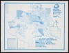
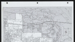
COMMUNITY DEVELOPMENT CODE /WAP
Established - Areas of the City already entirely built-ip or to the point that the basic land use pattern, lot sizes,, etc., are established and likely to remain unchanged during the next 20 years. Developing - Areas of the City essentially vacant which are within the Regional Urban Growth Boundary and thus deemed necessary fee anticipated growth during the next 20 years. Areas which have necessary urban services and facilities available or have been assessed for such, will generally develop before other essentially vacant lands.
Redeveloping - Areas of the City developed but are either blighted, under-utilized <x functionally obsolete and likely to change during the next 20 vears.
Special Purpose Districts - Are shown on the ccnmunity Development Cede Map* Three Physical Constraint Districts are identified and are overlain on the land use designations of the Ccnmunity Development Plan Map. The boundaries of the Physical Constraint Districts are close approximatiens. Properties shewn to be within a Physical Constraint District will submit information during the development permit process to ascertain which portions of subject parcels are within Physical Constraint Districts.
Floodplain Physical Constraint District - No development will be permitted on portions of property within the 100 year floodplain. The District is overlain cn the lew Density Residential land use designation.
Hillside Physical Constraint District 15% - 35% Slope - This District also occurs entirely within tHi low density residential land use designation. Special development standards and soils and engineering reports are required. Minimum lot sizes range from 14,000 square feet to 29,000 SCTuare feet, depending upon the degree of slope.
Hillside Physical Constraint District - Greater Than 35% Slope - Ihis District occurs entirely within the low density residential land use designation. Land Division will not be permitted in this District. Property which is entirely within this district may be improved to the extent of one dwelling unit for existing lots of record. Subdivisions of land which include this district in portions of the property shall not develop those lands which are in excess of 35% slope.
o
CO
o>
XF
Established District Developing 223 Redevelop ng wmm 100 \bor flood plan
15-35* Slope y Special forpose Districts >35* Slope
¡Bowidofies of Speocl Purpose Districts are dose approximations Boundaries
PUBLIC HEARINGS
on
Greshams
i Comprehensive! IPlan 7N\ =
fcnasHam^y
I __.
MULTNOMAH COUNTY LIBRARY
(Library Association of Portland, Ore.)
Extent
- 2 images
Contributors
Digital Publisher
Subject.Topic
Subject.Place
Language
Rights & Usage
Rights undetermined (the copyright and related rights status of this work is unknown).
Identifier
- XXmap_000118
Type
Date.Range
Format.Original
File format
Shelf.Location
- OREGON 711.4097 G831
Add new comment