
Description
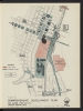
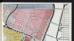
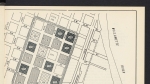
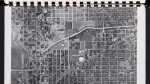
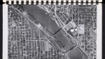
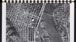
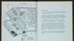
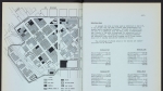
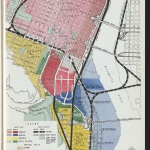
Map from a report published about 1956, showing plans for an expansion of Portland State College (now Portland State University) and for a new Exposition-Recreation Center, in the neighborhood immediately south of the Civic Auditorium (now Keller Auditorium). The map also shows new park blocks between SW 3rd and 4th avenues south of Chapman and Lownsdale squares, several parking decks, and freeway and bridge connections to the newly redesigned neighborhood. An extension of Highway 26 runs through downtown, with a connection to a new bridge over the Willamette. Harbor Drive improvements and a new bus line serve the Exposition-Recreation Center. The map includes space for the Pacific International Livestock Exposition near the Willamette River. None of these plans came to fruition, though the South Waterfront area was later redeveloped with a different design. Memorial Coliseum, the new Exposition-Recreation Center, was eventually built on the east side in 1960.
Download Files
Related content

Collections with this item
Details
Transcription
Contributors
Digital Publisher
Subject.Topic
Subject.Place
Language
Rights & Usage
Rights undetermined (the copyright and related rights status of this work is unknown)
Identifier
- XXmap_000107
Type
Date.Range
Format.Original
File format
Shelf.Location
- OREGON 711 P83so
Add new comment