\
\ 1.
\
N
R.R. AR&A.
13.
11.
CowtEmpos.ary Daily
Traffic Flow
(Vehicular)
Related to the
West Sire Fiat 4.%
or
POUTLAWD
Convu.it> to I*)21 bv TLF.. Kutnii*
September (921
f4A.
\
broad troy k Wash my/on
m>e. -5475
10.
1pT»Tt iao t\ -4 fe93/
9.
\
Length indicates the relative ro/ume of traffic passini tnt po/nt fnc/ioa/ed. r J
------/oo/ °f western fy/Z/s that border the west“ V
side f/nt \
Broac/woy w/tere /nM nsec ted by Ifafh/ngtonZh
¡Vest shore of tV///omette river:
B/r/POX TRA me represented hy 0,9,/O,//,/Z.
Gux erf TBATT/c, represented by ___________|
1. J+INNTQnnOAD Z02Q mfttACAÙA/7 nono 764 Ì At~~/)hniHe point^
2. Corno, road S83 oo«s terry roap 432)
3. Barnes road 340 ò./iair rnonne bridge .5444
4. Canyon road 32/ 9JVorrison Bridcx 4693
4A » to ad St. br/doe426 10J3or*ns/&£ Bn/nor $47S
5. Patton road 38/ 11 Stxxe »ridge £933
€. TknvriiL/axR Parnway567 103roadwaypmoex €330
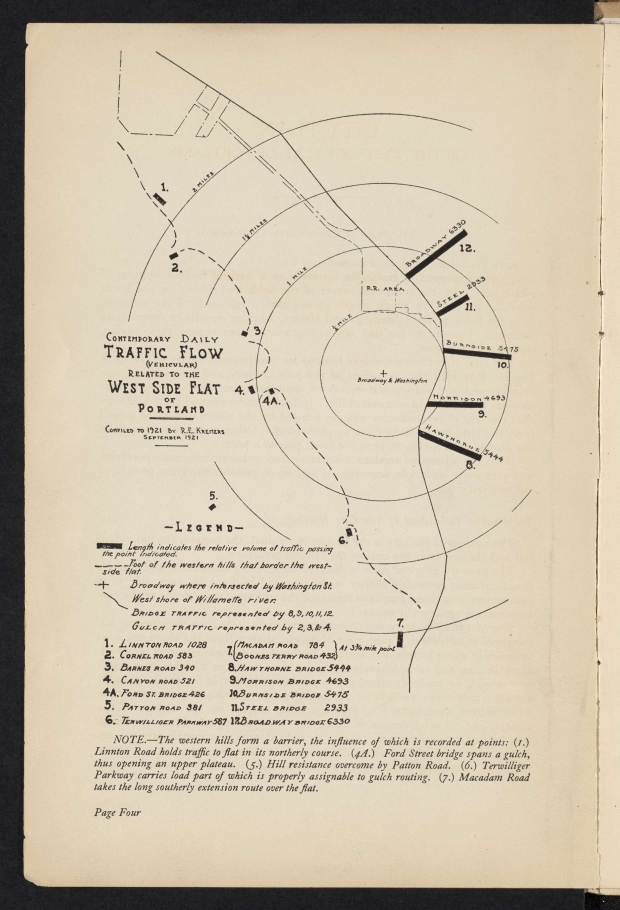
NOTE.—The western hills form a barrier, the influence of which is recorded at points: (/.) Linnton Road holds traffic to flat in its northerly course. (4A.) Ford Street bridge spans a gulch, thus opening an upper plateau. (5.) Hill resistance overcome by Patton Road. (6.) Terwilliger Parkway carries load part of which is properly assignable to gulch routing. (7.) Macadam Road takes the long southerly extension route over the flat.
Page Four
Add new comment