Description
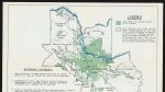
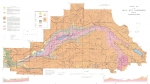
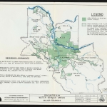
Map of Portland's city water system, produced approximately 1972. There are two areas shaded on the map: the Bull Run Reserve and the city of Portland. The Bull Run service area boundary is also shown. Dams on the Bull Run River, the water system's headwaters, the conduits carrying water west to the city, and several reservoirs are indicated on the map. Visit City of Portland Archives for more https://efiles.portlandoregon.gov/record/16821.
Related content
Collections with this item
Details
Digital Publisher
Subject.Place
Language
Rights & Usage
Rights undetermined (the copyright and related rights status of this work is unknown).
Identifier
- PUmap_000027
Type
Date.Range
Format.Original
File format
Shelf.Location
- A2014-001, M/10502
Add new comment