
Description
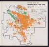
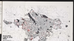
Map from a June 1956 report showing land use in the Portland area. City limits are shown for Portland, Fairview, Wood Village, Troutdale, Gresham, Milwaukie, Gladstone, Oregon City, West Linn, Lake Oswego, Tualatin, Beaverton, and Vancouver, Washington. This map was produced nearly 20 years before the adoption of Oregon's land use law in 1973, which requires urban areas to set boundaries to contain development.
Download Files
Related content
Collections with this item

Details
Transcription
Digital Publisher
Subject.Topic
Subject.Place
Language
Rights & Usage
Rights undetermined (the copyright and related rights status of this work is unknown).
Identifier
- XXmap_000112
Type
Date.Range
Format.Original
File format
Shelf.Location
- OREGON 352.9 O66pr
Add new comment