Description
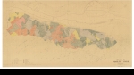
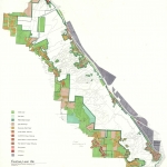
Hand-colored map showing land uses (e.g. residential, vacant land, industrial land) in the area immediately adjacent to Forest Park, and isolated parcels within the park. Park boundaries are shown with a dark green line. Map is part of the Forest Park Natural Resource Management Plan, dated November 1993. Visit City of Portland Archives for more https://efiles.portlandoregon.gov/Record/5986622/
Related content
Collections with this item
Details
Digital Publisher
Subject.Topic
Subject.Place
Language
Rights & Usage
Rights undetermined (the copyright and related rights status of this work is unknown).
Identifier
- XXmap_000155
Type
Date.Range
Format.Original
File format
Shelf.Location
- M/3149
Add new comment