Description
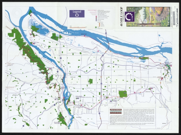
1993 Map of the partially completed 40-mile loop trail around Portland, showing bicycling, hiking and equestrian trails, and other recreational features. The Springwater Corridor, which the city acquired in 1990, is shown as an equestrian trail. Other popular trails are indicated on them map, including the Wildwood Trail in Forest Park, the I-205 path and the Marine Dr. bike path. The reverse side of the map features smaller maps of Kelley Point Park, the Wildwood Trail, Marquam Nature Park, Tryon Creek State Park, Powell Butte and Gresham's Main City Park.
Related content
Collections with this item
Details
Creator
Transcription
The 40-Mile Loop, as it has come to be known, was originally proposed in 1904 by the nationally-recognized Olmsted Brothers. These pioneer park planners were brought to Port-land from Boston to propose a park system as part of the planning for the Lewis and Clark Exposition.
The 40-Mile Loop was a truly remarkable concept in 1904, when the area was still largely woodlands and meadows. Fortunately, city leaders of the time had the foresight to recognize the importance of parks to a liveable community.
“Parks should be connected and approached by boulevards and parkways...They should be located and improved to take advantage of the beautiful natural scenery...The above system of scenic reservations, parks and park-ways and connecting boulevards would., form an admirable park system for such an important city as Portland is bound to become."
From System of Parks and Boulevards, “Report of the Park Bureau.” Olmsted Brothers, Landscape Architects, 1904, Portland, Oregon
When originally conceived at the beginning of this century, the trail was going to be 40 miles long, circling the city. Portland has done a lot of growing since then, and the trail was gradually expanded to include all of Multnomah County. When the loop is completed, hopefully by the end of the century, it will be 140 miles in length and connect more than 30 parks in the metropolitan Portland area.
When completed, the trail will connect parks along the Columbia, Sandy and Willamette Rivers in a continuous loop. There will be something for everyone, whether it is hiking, biking ... or even canoeing. Canoe trips as long as five miles will be available in the Columbia Slough.
The loop will also include trail access for the handicapped and nature trails for children. And, it will be accessible by Tri-Met buses at many points, and close to industrial and office workers interested in noon-time walking or jogging.
All citizens of this area have inherited this dream. Within miles from our homes are day trips, hiking, biking, camping and canoeing ... all are part of the 40-Mile Loop. Now, more than ever, appreciation of open spaces is basic to the quality of our lives.
It is time to complete the Loop.
The 40-Mile Loop Land Trust was incorporated in 1981 with the purpose of assisting in the acquisition of lands, along with conservation and recreation easements along the 40-Mile Loop corridor.
The Land trust, a non-profit, private land acquisition organization, brings together the park planning activities of 13 local jurisdictions, including:
* Multnomah County B City of Portland
■ Oregon State Parks Division ® Port of Portland
* Corps of Engineers
■ State & Federal Fish and Game Agencies
■ Public Drainage Districts
® Cities of Gresham and Troutdale
This cooperative venture has already proven to be cost effective. At a time of governmental cutbacks in parks programs, the work of a private, non-profit group such as the Land Trust in coordinating the various agencies and initiating land acquisitions saves the agencies time and money.
Helping make the Loop a reality is a big return for a small investment. Activities of the Land Trust will include:
■ Acquiring lands by using funds available in the Trust's revolving fund.
■ Accepting land donations by deed or by contract.
■ Accepting conservation easements or other rights to trail construction.
■ “Land banking” of properties for future transfer to public agencies.
■ “Pre-identification" of needed land along the corridor.
■ Advocacy of government funding for purchase and construction of trails.
■ Development of public access to the trail.
■ Help in forming local advocacy groups for management and use of parks.
Operations of the 40-Mile Loop Land Trust are financed by interested individuals, foundation and businesses. The Trust remains independent of any governmental body and is managed by the citizen board of directors.
Some of the ways in which you can be involved include:
■ Individual memberships
■ Donations and grants for specific projects
■ Gifts of land and easements for trails
■ Donations of tradelands for purchase of trails
■ Donations of bequest and wills
■ Memorials for trail development
For more information of the 40-Mile Loop and Land Trust, call (503) 241-9105 All contribution are tax-deductible.
Kelley Point Park is situated at the confluence of the Willamette and Columbia Rivers. A deciduous forest and large open meadow border the Columbia Slough northwest of Smith and Bybee Lakes. From the sandy beach along the Columbia, spectacular views of sailboats, steamers, tankers and barges illustrate Portland's maritime heritage.
Main City Park is a 17.5 acre park which provides wonderful recreation facilities and is a hub for the Gresham community, finking them to many recreation opportunities through the 40 Mile Loop/Springwater Corridor.
Map Design and Production Sutton Design Ventures
Original Art Christy Sutton
Printed By Irwin-Hodson
This is a small 6 acre urban wilderness park nestled in the flood plain of Johnson Creek. A special feature is the fish ladder, where trout, steelhead and occasional salmon can be spotted.
Columbia 6{oubk
A wonderful fink from Kelley Point Park through Smith Bybee Lakes on to Blue Lake Park. The slough includes wetlands, wildlife refuges for osprey, bald eagles, and herons. Navigable by canoe or kayak.
L&acV bo^MlcA
This is Portland's foremost wildflower garden. Located in a tranquil, wooded ravine straddling Johnson Creek, this 9 acre Botanical Garden features a labelled plant collection of 1500 plant species, educational facilities, exhibits, library and a gift shop. Garden entrance is off Foster Rd. at 122nd.
rfjAer-jroA fkek
This is a vital park for the downtown area and adds great beauty to Portland's skyline. It has many special features, including a fountain and several memorials.
OkMiwe tklvg f?A.\\
This asphalt trail parallels the Columbia River and offers many spectacular views of the river landscape, Government Island and Mt. Hood. This is a great trail for bicycling.
Coccidof
This is the first urban "rails-to-trails" in Oregon, coverting an abandoned railroad fine into a public recreation and bicycle commuting trail. It provides opportunities for walking, hiking, jogging, cycling, picnicking, bird and animal watching, and horseback riding. Eventually it will provide a link to Mt. Hood National Forest.
mi*
40 MILE LOOP
VANCOUVER
Printed in 1993, Portland, Oregon
Powell Butte is a large open hilltop, 570 acres, that was formed by volcanic action. From its 630 foot elevation summit, breathtaking views of the surrounding city and the mountains beyond abound. The top of the butte is an open meadow, with a stand of orchard trees interspersed and the forested slopes of the butte below. Home to a great variety of wildlife, the butte is a wonderful place for hiking, biking, horse back riding ana picnidng.
There are over nine miles of trail to explore. The Mountain View Trail is .6 miles of paved, with 5% grade level rest stops every 200 feet for wheelchair access. Special parking for buses and equestrain trailers can be reached at the intersection of Powell Blvd. and 162nd Avenue.
PORTLAND
GRESHAM
Mountain View Trail (wheelchair accessible)
BEAVERTON
Germanio^
Raymond St.
MILWAULKIE
AZJiiduJocd 'Trki I
The Wildwood Trail is the longest completed portion of the Forty Mile Loop. Twenty-three miles of forest trails connect, from the south, the Washington Park Zoo complex, Hoyt Arboretum, Pittock Mansion, and the Audubon House through to Springville Road, north, above the St. John bridge. Winding through second growth Douglas fir forest that harbors a wide variety of wildlife and native plant species, hikers and joggers are delighted with the seasonal displays of spring wildflowers and fall colors.
Additional brochures and maps along with interpretive information is available at the Hoyt Arboretum Tree House. The Wildwood Trail is not suited for bicyclists and there is one major street crossing at Burnside.
40 Mile Loop Trail
Mile Marker/Mile Segment Reference 40 Mile Loop Roadway Connection Other Trail Systems Roadways (Paved / Unpaved)
Trailhead with Information Kiosk and Off Street Parking Trailhead with Street Parking
Additional Parking
Restrooms
Special Trail Use:
^ Hiking v 0 Bicycling
Equestrian
iljflB I
Foster R<A.
IruoM Cfôôk 6\A& fkrk
Tryon Creek State Park is a 641 acre natural day use area located within the city limits of Portland. The park has 8 miles of hiking trails, over 3 miles of horse trails and 3 miles of bicycle trails.
Of special interest is the Trillium Festival each year. Tryon Creek State Park has a wonderful trail named after this wildflower, and it is wheelchair accessible.
Marquam Nature Park
Hewett
Terwilllger
Boulevard
Park
Thompson
Council Crest Park
Thurman St.
m UAufò fkrk
Trillium Trail (Wheelchair access!
Marquam Nature Park winds through the West Hills, surpising city dwellers with a wonderful quiet retreat close to the downtown core. The park connects the Washington Park Zoo/World Forestry Center/Vietnam Memorial complex to the north through Council Crest, and to the south reaches Willamette Park through Terwilfiger Boulevard Park and George Himes Park. Most of this trail section passes through Douglas fir forest, but spectacular views are part of the attraction from the top of Council Crest.
A map showing internal loop trails and histoy of the area are on display at the Interpretive Center off Sam Jackson Road near Duniway Park.
<fOfe&\ fork
Lovejoy St.
fiWock i$\Ae
This is one of our region's great mansions. This historic residence displays remarkable antique furnishings, fine arts and a sweeping view on a picturesque setting.
Five traditional garden forms combine to recapture the mood of ancient Japan. The gardens meander over 5.5 acreas of woodlands that open onto a breathtaking view of Portland.
RS<Afdo\A$
More than 400 varieties of modem roses and many old garden roses are in this beautiful setting with a commanding view of Portland and Mt. Hood.
VietiAAW 'AemoriA
This Memorial with it's serene landscaping is a wonderful tribute to Oregon's Vietnam Veterans.
fhrlc Zoo
This is Portland's oldest, best-loved and well-used parks. The zoo exhibits over five hundred species, with an internationally famous breeding herd of Asian elephants.
‘TfoJ Adpooebm
Temmiles of trails lead visitors through one of the nation's best collections of conifers, flowering magnolias, exotic maples and other special groupings of plants.
Audubon 'ftovse
This is a great place for bird lovers. The expanded facility has a girt shop, library, and lecture rooms for many activities.
/¿¿odd ^ooeslrn CmW
This exhibit hall pays tribute to Oregon's treasures,
Audubon House
ttock Mansion
Skyline
Japanei
GardA
Carolina St.
George
Himes
Park
ibrask
liarnefj
Wiliam
Vietnam Memorie !• World Forestry Cent« !•
• Washington Pari
IP1
See Marquam Nature Park inset
See Forest Park Inset
J>rtr 0 S 1-405 IffH 1 $ f rl 03 ^ m
1
S
li)
■í
PKELLEY P0JNT PARK
SMITH A (¡ID BYBEELAKES
DELTA WEST
DELTA EAST
CATHEDRAL PÀI
Germant.
Ainsworth St.
Külingsworth St.
Klllinasworth St.
FOREST PARK
BLUE LAKE PARI
Marine Pr.
LEWIS AND CLARK ’STATE PARK
IACLEAY PA RK
TROUTDALE
FAIRVIEW
TROUTDAl
COMMUNIS/
XIKU PARK
'Urnside Rd.
Burnside St.
Mt. Hood
Stark St.
PORTLAND
Community
College
Sweet Briar Rd.
MARQUAM N^URE PAR
Division St.
Division St.
Proposed Beaverton Creek Trail connection to Haag Lake
MAIN CITY PARK
COUNCIL
CREST
PARK
Powell Blvd.
Powell Blvd.
POWELL BUTTE
Holgate St.
Holgate St.
GRESHAM
Palmquist Rd.
Beaverton Hillsdale Hwv.
Harold St.
CRYSTAL SPRII* GS
RHODODENDRON GARDEN Woodstock Blvd,
BEGGARS TICK I MARSHI
GEORGE
3 HIMES. PARK
Foster Rd,
lwlLLAM
/PARK
LEACH
-BQTANIÇAL
GARDEN^
PffwoOD WE®T
IVERFRONT f]
ELAND PARK
Flavel St.
Crystal i 'prings
Mt. Scott Blvd.
Tacoma St.
YÌDEM W/JOl PARK
MILWAI
TIGARD
TRYON CREEK STATE PARK !
SPRINGWATER
Legend
1 mile
2 miles
■.. ■ 40 Mile Loop Trail
'---- Mile Marker/Mile Segment Reference
............... 40 Mile Loop Roadway Connection
............. ■■ Future 40 Mile Loop Trail
...... Other Trail Systems
• > .. .. .. i other Future Trail Systems
Q Trailhead with Information Kiosk
Ü Trailhead with Street Parking f3 Additional Parking H Restrooms
Special Trail Use:
O Hiking Bicycling Equestrian
Parks
. Wetland Areas
roposed
ironson Creek I rail connection to laag Lake—
Scale
0 miles
The acquisition of Springwater Corridor by the city of Portland in 1990 was a giant leap towards completion of the 40 Mile Loop, and closed the last major gap in the loop. The 16.5 mile long Corridor begins at Milwaulkie Blvd. and extends to the community of Boring. It was originally developed for rail service and was most commonly known as the Portland Traction Company Line. It has a smooth, even grade which makes it ideal for many types of recreation use.
True to the initial inspiration for the Loop, many parks and open spaces are linked by this addition. Just as the railroad was the lifeblood of the communities it served, the Springwater Corridor/40 Mile Loop will continue to tie neighborhoods together and encompass many scenic areas, including Johnson Creek, wetlands, buttes, agricultural fields and pastures, residential and industrial neighborhoods. Parks include Oakes Bottom Wildlife Refuse, Oaks Amusement Park, Sellwood Riverfront Park, Johnson Creek Park, Sellwood Park, Tideman Johnson Nature Park, Beggars Tick Marsh, the 1-205 bike path, Leach Botanical Garden, Bundy Park, Powell Butte Nature Park and Gresham Main City Park.
The original rail line continued beyond Boring and is currently owned by the State. The addition of this link offers a real possibility of a trail that would link downtown Portland directly with the Pacific Crest Trail.
BORING
Hwy. 212
4*
M0000961
Extent
- 2 images
Contributors
Digital Publisher
Subject.Topic
Subject.Place
Language
Rights & Usage
Rights undetermined (the copyright and related rights status of this work is unknown).
Identifier
- XXmap_000070
Type
Date.Range
Format.Original
File format
Shelf.Location
- OREGON MAP 912.79549 F745 1993


Add new comment