Description
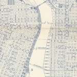
Map of downtown Portland near the Willamette River harbor wall, dated January 9, 1968. Map shows the extent of serious floods that took place in 1894 and 1948, with elevation data at intersections and other key points on the map. The map outlines detailed plans for caulking and sandbag operations along the harbor wall, in case of a flood. Harbor Drive is shown along the riverfront, from SW Columbia St. to the Steel Bridge. Visit City of Portland Archives for more https://efiles.portlandoregon.gov/record/16652
Collections with this item
Details
Digital Publisher
Subject.Topic
Subject.Place
Language
Rights & Usage
Rights undetermined (the copyright and related rights status of this work is unknown).
Identifier
- PUmap_000022
Type
Date.Created
January 9, 1968
Date.Range
Format.Original
File format
Shelf.Location
- A2013-007, M/10333
Add new comment